CAI
SERVICES
"NEED A DRONE SERVICE?"
Coast Aerial Imaging is a bonded and insured LLC company with over 30 years of photography, video and UAV experience. We can offer a wide range of UAV services using proven high quality equipment. We offer fair pricing and free site assessments if required. You can find more detailed answers to your questions by visiting our FAQ section of this website or send us a question by clicking on the CONTACT button and we’ll respond promptly.
BEST VIEWED IN 4K
"3D Mapping"
Photogrammetric or Orthomosaic imaging is typically a map, drawing, or 3D model of an object or scene that can be measured. Maps today can be produced using full-scale aircraft, satellites, or drones. CAI can capture photos and produce 2D or 3D images of your property or work site. Sometimes large projects may take as many as 5000 or more high-resolution photos to complete. All of the 3D models shown on this page are accurate and surfaces can be measured at or below 3 centimeters. CAI deploys the P1 camera system using a Smart Oblique flight path while using proprietary techniques to capture and render the highest resolution 3D maps.
So, this means that if you had a 3D model of your property you could easily measure the distance or the exact surface area of a new driveway. No more guessing about how many square feet of concrete or asphalt it will take to complete the job.
Would you like to know the exact surface area of your roof? We have you covered!
BEST VIEWED IN 4K
"Check The Box!"
- *Precision and Accuracy*
- *Time and Cost Efficiency*
- *Rapid Data Collection*
- *Remote Accessibility*
- *Safe Operations*
- *Real-time Monitoring*
- *Volume and Area Measurements*
- *Surveying and Mapping*
BEST VIEWED IN 4K
"Ask Questions"
Most clients who want to hire a UAV company may not fully understand how drones work and what information they can provide. Your service provider should demo all the possibilities and how you might use the service. For less knowledgeable clients, it is best to actually see examples of what is possible. You may think you are looking at a great picture until you see a high-quality one next to it. We hope the videos on this page will help. More examples will be uploaded in the future. If you have questions please CONTACT us!
BEST VIEWED IN 4K
"Equipment Matters"
Traditional surveying and mapping methods can be time-consuming and may not provide as detailed information. Drones can rapidly cover large areas, creating high-resolution maps and 3D models.
These benefits make drone 3D modeling a powerful tool across various industries, contributing to improved efficiency, safety, and decision-making processes.
All 3D models produced by CAI are rendered at the highest possible resolution using proprietary techniques that have been developed over the last 7 years BUT every high-quality map or 3D model starts with a good high-quality photo. CAI feels confident you will not find a 3D model with more detail.
BEST VIEWED IN 4k
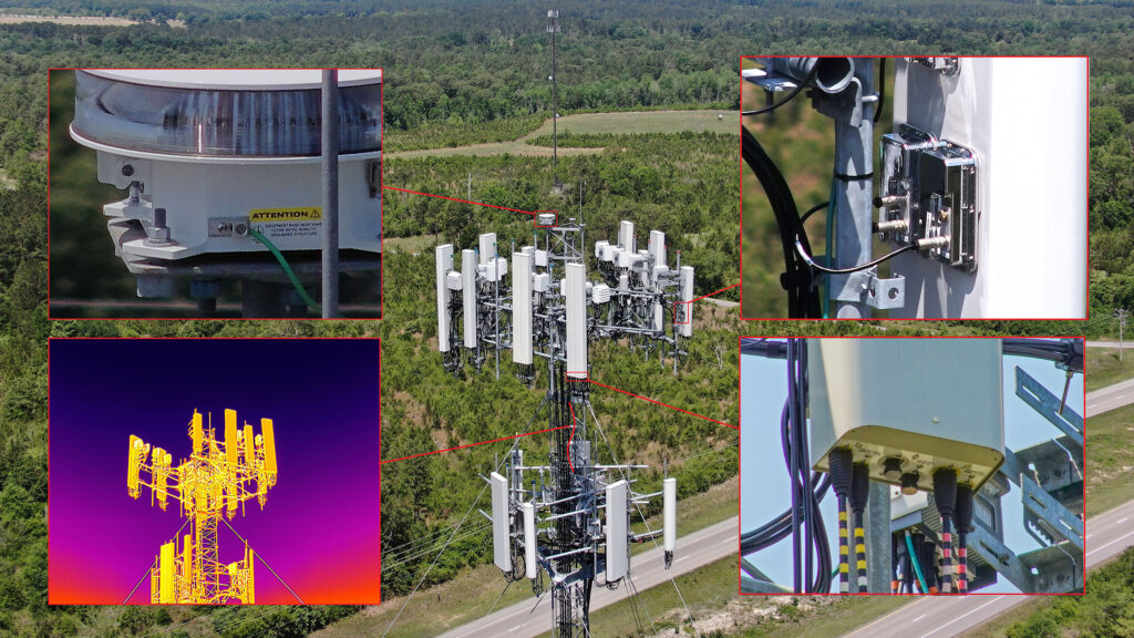
"H20T Capabilities"
The zoom and thermal capabilities allow the opportunity to zoom in on objects for a crystal clear picture at safe stand-off distances. By using a UAS and camera system that is IP-compliant, paired with the RTK ground station, our equipment can fly safely in challenging conditions that would ground other systems. This picture is a good example of the H20T in action and demonstrates the quality of the zoom camera.
See an example of our Thermal Scan Report.